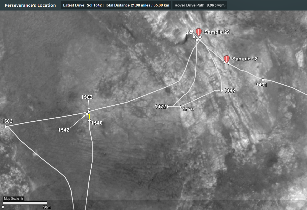
The drive path is highlighted yellow

Just in case you'd missed it: You can turn parts of the map on and off on the Berlin map, eg those camera icons and the rover's current location + See this screen shot

It's a good map, very useful :)
The drive path is highlighted yellow
The details are extracted from JPL's public JSON URLs that provide waypoint and traverse data, these are updated shortly after each drive. Credits: NASA/JPL-Caltech

Composite image using 6 overlapping processed NavCam tiles acquired after the drive to site 76.594. Roughly assembled in MS-ICE. Credits: NASA/JPL-Caltech
Not looking good. Sol 1548 NavCam tile (processed (NASA/JPL-Caltech)
Third time's a charm? Or time to move on? I'd say go for it again

Nice animation :) Definitely an improvement on the earlier attempt, we see still see some some fracturing, but a lot less movement (side-to-side) movement of the drill (maybe more down-force on the support pillars?). We'll have to wait for the post abrading images after they move the turret away from the site so see what they have achieved. Whatever the results of this abrasion the fact that it readily breaks up, attempts to retain a core will likely be difficult.
Fingers crossed :)
Nice ~~cheat~~ observation :)
I'm assuming that this was where the patch was meant to be.
Any bets regarding another try close by?
I'm sure they have a ton of drill data, hopefully they'll share something soon :)
As for your missing patch names looks like you have to wait until Early August for the next update

Looks to my old eyes like the surface layer broke up and was scattered around. As you say there appears to be some movement of the turret / robotic arm, so I believe you're spot on in predicting that the abrading process was likely ended early. We'll have to await for those post abrasion images. Let's hope it's not like the previous patch where we had to wait days for the drill to be moved.
BTW, Do you have a list of patches that you don't yet have a name for (before sol 1380)?
That's extremely useful. Pity they don't release the names of all the patches in the updates. I know we'll eventually see the names in the mission managers reports, but those are many months away.
Annotated screen capture of the official map - Credits: NASA/JPL-Caltech/MSSS/UofA
The raw data is provided by NASA/JPL after each drive

4-tile post-drive NavCam - Credits: NASA/JPL-Caltech

Huge difference. It's a pity we have to suffer the current limits for data transfer between Earth and Mars. Some of the orbiting assets are aging rapidly, so data limits are not going to improve any time soon, else we could hope for many more images at different times of the day.
Credits: NASA/JPL-Caltech/MSSS/UofA

The drive distance may be amended later as there are 2 official data sources, and the one I don't usually use indicates the distance was a little longer at 405.49 m. I've decided to report on the shorter one for the time being

end-of-drive upper tier NavCam looking south after the second longest daily drive since landing. Credits: NASA/JPL-Caltech.

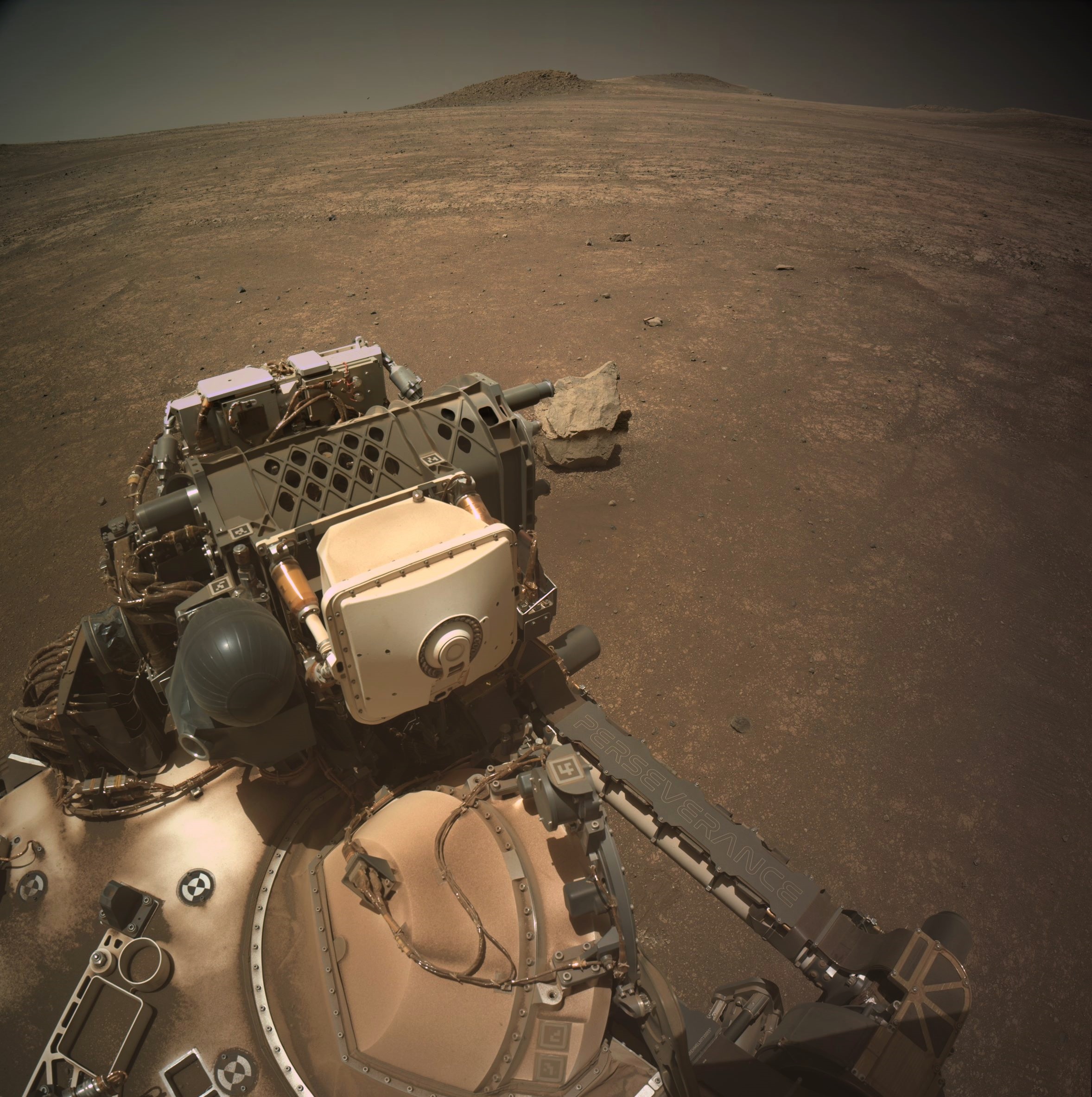
Perseverance rover acquired this image of the coring bit located in the Carousel using its SHERLOC WATSON camera, located on the turret at the end of the rover's robotic arm. The image has been rotated to correct the orientation of the carousel.
This image was acquired on June 18, 2025 (Sol 1538) at the local mean solar time of 15:21:21.
Image Credit: NASA/JPL-Caltech

I'd hazard a guess that is why they returned to this area. Yes the rock is readily fractured, but possibly better cemented than those further west and south. We'll see if they try a new abrasion or just go for a core :)