this post was submitted on 04 Aug 2024
724 points (91.0% liked)
Facepalm
2560 readers
7 users here now
founded 1 year ago
MODERATORS
you are viewing a single comment's thread
view the rest of the comments
view the rest of the comments
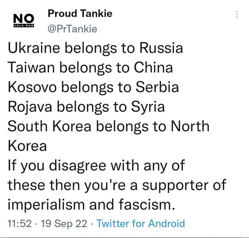
FWIW, the full list of disputed territories is much longer than you think. Basically, every map in existence is also picking sides whether they know it or not; a realization I find chilling.
https://en.wikipedia.org/wiki/List_of_territorial_disputes
For some of them Google and other map providers have to show the territory as belonging to whichever you're in.
So if you're in India, it shows Kashmir as Indian, but if you're in Pakistan, it shows it the other way round. I've no idea what it shows if you're actually in Kashmir.
That's a good question. Maybe neither? Or perhaps it belongs to itself?
Hasn't been Kashmir in nearly a decade. The Indian military invaded and formally began occupying the province back in 2015. They've got something like 900,000 troops spread in and across the country as of 2019. Roughly one soldier for every eight Kashmiri citizens.
We hear virtually nothing of it in Western media, of course. Modi's India is a western ally, so it is beyond repute. But the invasion of Kashmir has created its own regional refugee crisis and international heightening of tensions not seen since the worst days of the Cold War.
Which also helps spread the opinion among both populations that it is rightfully theirs
Like when China casually released a map with redrawn borders?
Exactly
Even maps of Canada can appear different depending on whether the map comes from Quebec or Labrador.